

Post-Fire Hillslope Erosion – Eaton Fire 2025
Modeled first-year hillslope erosion rates for the January 2025 Eaton Fire in Los Angeles County, California: a pre-fire baseline, a post-fire surface, and the modeled increase, with per-basin and per-watershed summaries. A proof-of-concept demonstrating rapid translation of post-fire science into an open, citable data package.

About this dataset
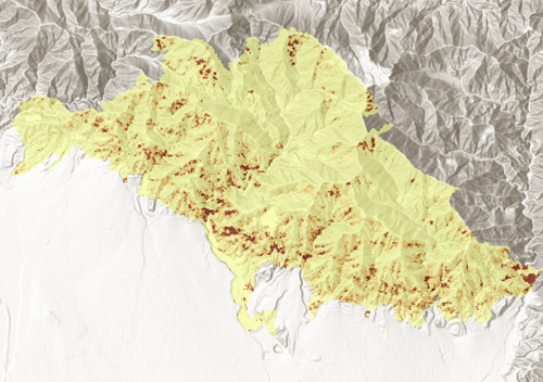
This package contains modeled first-year hillslope erosion rates in tons/acre/yr across the Eaton Fire burn: a pre-fire RUSLE baseline, a modeled post-fire surface, and the modeled increase between them. Multipliers were learned from a Difference-in-Differences analysis of 16 Southern California fires (2020–2024) and applied to the Eaton Fire's BAER/BARC soil burn severity map; the Eaton Fire was not part of the training set. The modeled footprint covers about 11,400 acres.
This is a prototype, not an operational service. Values are modeled estimates, not field measurements. The data map hillslope erosion only — not debris-flow, flood, or delivered-sediment hazard — and make no treatment recommendations. The data inform decisions; responders make them.
What’s included in this dataset
How to interpret this layer
- Erosion rasters (3) – pre-fire baseline, modeled post-fire surface, and modeled change, Cloud-Optimized GeoTIFF, EPSG:26911, tons/acre/yr
- Basin summary the 90 USGS post-fire debris-flow hazard assessment basins carrying VPDC per-basin erosion summaries (GeoJSON + CSV)
- Watershed summary – totals for the four HUC12 watersheds intersecting the burn (CSV)
- Severity-class multipliers – the learned per-class erosion-change multipliers with their full per-fire distributions (CSV)
- Documentation – README, data dictionary, limitations, provenance sidecars, checksummed manifest, license and notices
Explore the full Data Story
To dive deeper into the methods, context, and example applications behind this dataset, explore the full VPDC Data Story that accompanies it.
See the full Data Story ⭢How to get started
Download
Post-Fire Hillslope Erosion – Eaton Fire 2025
Modeled first-year hillslope erosion rates for the January 2025 Eaton Fire in Los Angeles County, California: a pre-fire baseline, a post-fire surface, and the modeled increase, with per-basin and per-watershed summaries. A proof-of-concept demonstrating rapid translation of post-fire science into an open, citable data package.

Direct Download (Full File) - HTTPS Link
Use this link to download the entire file directly to your local storage through the browser. This method is ideal for quick and easy access but requires sufficient local storage and bandwidth for the full download.
Download data:


Complete data package (ZIP)
Full data package, containing all data in one download: three erosion rasters, basin and watershed summaries, learned multipliers, and full documentation with a checksummed manifest. Mirrors the loose files exactly.
Pre-fire erosion baseline (COG)
Modeled pre-fire annual hillslope soil-loss rate, tons/acre/yr. Cloud-Optimized GeoTIFF on the analysis grid (EPSG:26911).
Modeled post-fire erosion (COG)
Modeled first-year post-fire soil-loss rate: pre-fire baseline times the learned severity-class multiplier, tons/acre/yr. EPSG:26911.
Modeled erosion increase (COG)
Modeled increase in soil-loss rate (post minus pre), tons/acre/yr, as delivered by the science team and verified against recomputation. EPSG:26911.
Hazard basins + per-basin erosion summary (GeoJSON)
The 90 USGS post-fire debris-flow hazard assessment basins carrying the VPDC per-basin erosion summary and locality labels. USGS geometry and attributes unmodified, public domain.
Per-basin erosion summary (CSV)
The per-basin erosion summary as a flat table: totals, rates, severity composition, and shares for the 89 basins with modeled burn. Joins to the basins layer on SegmentID.
Heading
Explore scenario data downloads
Use the filters, then click a group to reveal individual downloads.
Download tiled data:
Selected Data Tiles:
Direct Access
Get hands-on access to this dataset using interactive notebooks. Choose between the Google Colab notebook for quick exploration in your browser or access the hosted Jupyter Notebooks via Binder or GitHub for more advanced workflows.

Direct access to the Google Collab notebook
Open and explore instantly
Click the button to the left to launch an interactive notebook directly in your browser. This pre-configured Colab notebook provides a quick and easy way to explore, visualize, and analyze the data—no setup required.
GitHub hosted Jupyter Notebooks
Flexible access for advanced workflows
Access the full collection of Jupyter Notebooks hosted on GitHub. These notebooks can be used on your local machine or via cloud platforms like Binder or Google Colaboratory, providing flexibility for more advanced customizations.
Licensing & Attribution
Licensed under Creative Commons Attribution–NonCommercial–ShareAlike 4.0 International (CC BY-NC-SA 4.0).
You may share and adapt this dataset for noncommercial purposes with attribution under the same license.
Required Attribution:
© 2026 Vibrant Planet Data Commons. Distributed by Vibrant Planet Data Commons. Licensed under CC BY-NC-SA 4.0. USGS and WBD content in this package is U.S. public domain and is not relicensed; see the package NOTICE.
For commercial or special-use requests, email us at contact@vpdatacommons.org
Disclaimer
This dataset is a proof-of-concept prototype. Values are modeled estimates of hillslope erosion only and are not field measurements, debris-flow predictions, or treatment recommendations.
Vibrant Planet provides the information hosted on the Vibrant Planet Data Commons site (www.vpdatacommons.org) (the “Site”) as a PUBLIC SERVICE for NONCOMMERCIAL USES only. The information is provided as-is, as-available, and without warranty of any kind, whether express, implied, or statutory, concerning the accuracy, completeness, reliability, or suitability of the information. Further, we do not warrant that this site will (i) be uninterrupted or error-free; or (ii) result in any desired outcome. We are not responsible for content of other services, data or public information that may be used by or linked to this site. By accessing this website and/or the data contained within, you assume the entire responsibility and liability related to the use of the information it contains, and you release Vibrant Planet Data Commons, Vibrant Planet and all data providers from liability. You may use the Site only for lawful purposes Users also should note that property boundaries included on any map do not represent an on-the-ground survey suitable for legal, engineering, or surveying purposes. They represent only the approximate relative locations. We reserve the right to withdraw or amend this Site, and any service or material we provide on the Site, in our sole discretion without notice. We will not be liable if for any reason all or any part of the Site is unavailable at any time or for any period. From time to time, we may restrict access to some parts of the Site, or the entire Site to users or visitors to the site. The Site and its entire contents, features, and functionality (including but not limited to all information, software, text, displays, images, video, and audio, and the design, selection, and arrangement thereof) are owned by Vibrant Planet Data Commons, its licensors, or other providers of such material and are protected by United States and international copyright, trademark, patent, trade secret, and other intellectual property or proprietary rights laws. This site is operated by Vibrant Planet Data Commons.