Alternative Futures: 
How Climate Analog Models Can Guide Land Management

From the University of Montana and partners at USFS, Conservation Science Partners, and Vibrant Planet
Supported by NWCASC
Access Data

Vegetation Futures

EXECUTIVE SUMMARY

KEY POINTS: 30-Second Brief

The Approach

  • Climate analogs as evidence: Where today's climate already resembles a location's projected future, today's vegetation is observable evidence of what could grow there under mid-21st century warming.
  • Ranked outcomes, not predictions: The model produces a primary and secondary projection — a plausible range of futures, not a single deterministic forecast.
  • Western U.S. scale: ~3.2 million km² of forests, woodlands, shrublands, and grasslands from the Pacific Coast to the Rocky Mountain Front.

Key Findings

  • Widespread transformation risk: ~29% of the western U.S. faces high or very high vulnerability; vegetation-type change is projected across 40% of the study area.
  • Subalpine forests most at risk: Climatically suitable subalpine area is projected to contract by 54% — the most consistent finding across projection levels.
  • Uncertainty is signal, not noise: Where primary and secondary projections diverge, multiple trajectories are genuinely plausible — and management may determine which one unfolds.

For Managers

  • Four decision contexts: The combination of vulnerability and projection agreement defines whether to maintain, prepare for transition, watch for signals, or act with local knowledge.
  • RAD framework fit: High vulnerability + high agreement supports accepting or directing change; low vulnerability supports resistance; low agreement is where management has the most leverage.
  • Use the tool: The Vegetation Futures Tool is free at https://vegetationfutures.org/ — draw your management unit, generate a downloadable report, and explore the data.
Navigating Ecological Transformation in the Western U.S.

Western ecosystems are already transforming. Wildfires, drought, insect outbreaks, and shifting climate are catalyzing changes in vegetation that will reshape landscapes, ecosystem services, and management realities for decades.

For land managers, researchers, and conservation practitioners, the question is no longer simply what might change. It is where change is most likely, what trajectories are plausible, how certain we can be about those projections, and what options remain.

Planning under uncertainty has become the norm. But uncertainty is not necessarily a barrier to action. In some places, it signals that multiple ecological futures remain possible — and that management decisions may still influence which one unfolds.

Standing snags in the Dixie Fire burn area, Lassen National Forest, California. The Dixie Fire (2021) burned over 960,000 acres — the largest single wildfire in California's recorded history — converting mixed conifer forest to open shrubland and early-seral communities across much of its footprint. Photo: Adobe Stock

A hillside showing active forest mortality from fire and drought stress, Oregon. Mosaics of living and dead forest are increasingly common across the western U.S. as overlapping stressors — drought, bark beetle outbreaks, and high-severity fire — accelerate vegetation change beyond historical ranges. Photo: Adobe Stock

This data story introduces the Vegetation Futures work: a suite of climate-analog models, associated datasets, and an interactive web application that project which vegetation types a warmer future climate could support across the western United States — and where those projections converge or diverge. The study area spans the western United States: approximately 3.2 million km² of forests, woodlands, shrublands, and grasslands from the Pacific Coast to the Rocky Mountain Front. The work was led by the University of Montana, the USDA Forest Service, the Northwest and North Central Climate Adaptation Science Centers, Conservation Science Partners, and Vibrant Planet* and published in Global Change Biology1.

What Are Climate Analogs?

Finding tomorrow’s climate in today’s landscapes

The climate-analog impact modeling pipeline. For each focal location, the model identifies analog locations — places whose current climate already resembles the focal location's projected future — and tallies their vegetation types by weighted vote. The result is a ranked set of plausible futures, not a single prediction. Analog selection is constrained to geographically nearby locations to reflect regional ecology and realistic dispersal distances. Adapted from Hoecker et al. (2026).

For every location in the western United States, the Vegetation Futures modeling framework asks a deceptively simple question: Where, today, does the climate already resemble what this location is projected to experience in a warmer future?

Those locations are called climate analogs. And the vegetation they currently support provides observable evidence for what a warmer future climate could sustain at the focal location. 

This approach treats the landscape as a natural experiment. Rather than simulating how ecosystems respond to changing conditions through modeled ecological mechanisms, it identifies locations where the projected future climate already exists and asks what vegetation those climates currently support. That is the foundation of climate-analog impact models, or AIMs1
How the model works
For each focal location across the western United States, the model identifies a set of analog locations — places whose current climate closely matches that focal location's projected future climate. Analogs are constrained to geographically nearby locations, so the results reflect regional species pools and realistic dispersal distances rather than climatically similar but geographically distant places. Climate similarity is assessed using four variables that capture moisture availability and temperature extremes — the primary drivers of vegetation distribution in the western United States.2 Climate data are downscaled to approximately 220 meters using TopoTerra,3 a topographically informed climate product that represents the effects of slope, aspect, and landscape position, distinguishing, for example, the warmer and drier conditions typical of south-facing slopes from the cooler, moister conditions of north-facing slopes.
Once analog locations are identified, each one "votes" for the vegetation type that is expected for that focal location in the future. Votes are weighted by how closely each analog matches the target location's future climate — a closer climate match carries greater influence. The vegetation type with the most weighted votes becomes the primary projection. The second most supported type becomes the secondary projection.

The result is not a single deterministic outcome. It is a ranked set of plausible vegetation trajectories — more like a contested election than a settled forecast. And that distinction matters.
Weighted analog voting produces ranked projections. Each analog location casts a vote for the vegetation type it currently supports, weighted by its climatic similarity to the focal location (shown as Mahalanobis distance values). The votes are summed to produce a primary projection — the most climatically supported outcome — and a secondary projection. Where votes are split across multiple vegetation types, that division is itself informative: it reflects genuine uncertainty about which trajectory will unfold. Adapted from Hoecker et al. (2026).

Weighted analog voting produces ranked projections. From a pool of potential analogs within 500 km of each focal location (black star), locations that are climatically similar (grey shading) and geographically near (inside dashed line) are retained.  Each analog location casts a vote for the vegetation type it currently supports, weighted by its climatic similarity to the focal location (measured using Mahalanobis distance, shown inside boxes). The votes are summed to produce a primary projection — the most climatically supported outcome — and a secondary projection. Where votes are split across multiple vegetation types, that division is itself informative: it reflects genuine uncertainty about which trajectory will unfold. Adapted from Hoecker et al. (2026).

What analogs are not
Climate-analog models project what vegetation a future climate could support at a given location. They are not forecasts. They project what vegetation the future climate could support, not what will definitively grow there. AIMs do not simulate ecological processes like disturbance, dispersal, competition, or establishment—those dynamics are where local knowledge and management expertise enter the picture. And they are not a replacement for that local knowledge. They are complementary to it.

Introducing the Vegetation Futures Tool

From projections to planning context

The Vegetation Futures web application, built by Gage Cartographic, translates the research outputs of Hoecker et al. into an interactive platform for exploring potential vegetation transformation. It is freely available at vegetationfutures.org.

The tool is organized around three time periods: Current (reference period, 1961–1990), +2°C Future (mid-21st century), and Delta (the projected difference between the raw climate variables). Users can explore each period independently or use the compare mode — which snapshots the current map state and pins it alongside a second layer, with a slider bar to examine shifts across the same area.

The Vegetation Futures web application displaying primary vegetation projections under a +2°C future climate scenario. The tool supports side-by-side comparison of current and future vegetation layers, with toggles for vulnerability, projection agreement, and climate variables. The polygon analysis tool allows users to define a management unit — by drawing or uploading a shapefile — and generate a downloadable report for use in planning documents and vulnerability assessments. Available at vegetationfutures.org.

Model Projection layers (available for +2°C Future and Current):

  • Primary and secondary vegetation. The most- and second-most-supported vegetation types at each location under the selected climate scenario, ranked by climatic support across the 100 analog locations.
  • Vulnerability to ecological transformation. The degree of difference between vegetation communities supported by future and reference-period climates at a given location. Measured using Bray-Curtis dissimilarity [1], vulnerability ranges from low (future vegetation resembles current) to very high (a fundamentally different community is projected).
  • Projection agreement. The degree to which climate analogs converge on the primary projection. High agreement indicates strong convergence; low agreement indicates multiple vegetation types are nearly equally supported, and that factors beyond climate — disturbance, seed sources, management — may determine which trajectory unfolds.
  • Index of vulnerability and projection agreement. The combined view of these two metrics and the primary decision-relevant layer. This distinguishes locations where transformation is both likely and well-supported from those where outcomes remain contested. Section 5 develops this further.
  • Distance to closest future vegetation type. The geographic distance between the focal location and the closest current example of its projected future vegetation type — a coarse indicator of how far that vegetation type would need to disperse to establish locally.
  • Climate layers (Maximum Temperature of July, Minimum Temperature of January, Actual Evapotranspiration, Climatic Water Deficit) are also browsable directly, allowing users to examine the underlying climate signal driving each projection.

Analysis and download

Users can overlay National Parks and USFS District boundaries as reference layers. The polygon analysis tool supports drawing a custom area or uploading a shapefile to generate data tables, graphs, and a downloadable report for a specific management unit — suitable for inclusion in planning documents and vulnerability assessments.

Raster data are available for download in two modes: the full western U.S. dataset, or a clipped version scoped to the user's current map extent. Available datasets span current and +2°C vegetation projections, climate data, distance, vulnerability, agreement, and the climate delta layers.

The tool is live. Use it here.

The Vegetation Futures application is embedded below — not a screenshot or preview, but the working tool. Navigate to any area in the western U.S., toggle the layers described above, and use the polygon tool to draw a management unit boundary and generate a downloadable report without leaving this page. The full-screen experience is available at vegetationfutures.org.

Hoecker et al. (2025). Vegetation Futures Tool. University of Montana, Northwest CASC, North Central CASC, USDA Forest Service. https://doi.org/10.17605/OSF.IO/W6JVK | Open full tool ↗

What the Projections Show Across the West

The Vegetation Futures models project widespread potential for ecological transformation. Approximately 29% of the western United States — nearly one million square kilometers — faces high or very high vulnerability to vegetation transformation1. At the vegetation-type level, transformation is projected for 40% of the study area, approximately 1.4 million square kilometers1. These findings represent the forests, rangelands, and watersheds that provide water, timber, habitat, recreation, cultural values, and carbon storage across the West.

The findings below are drawn directly from Hoecker et al. (2026)1. For the full quantitative treatment, readers should consult the published paper and explore the Vegetation Futures tool for their areas of interest.

Projected transformation direction for subalpine forests and woodlands. Orange indicates loss of climatic suitability; green, maintenance; blue, potential gain. Panel A shows the regional pattern across the Pacific Northwest and intermountain West, with insets over north-central Washington and central Idaho. Panel B zooms into the central Idaho inset, where the spatial structure of projected loss is concentrated and spatially consistent across the mountain landscape. Adapted from Hoecker et al. (2026).

  • Subalpine forests: high vulnerability, high agreement. The area climatically suitable for subalpine forests is projected to decline by 54% (approximately 106,000 km²), with high agreement across primary and secondary projections (54% and 60% respectively)1. Losses are concentrated in the Cascades, Northern Rockies, Sierra Nevada, and Central Rockies. The consistency across projection levels makes this among the most robust findings in the research.
  • Forested area: conservative estimate of contraction. The area climatically suitable for forests overall is projected to contract by 9%1. This should be understood as a conservative lower bound: it represents land where the future climate falls entirely outside the climate space currently occupied by any forest type. Additional forested areas could convert if transitions to different forest types do not succeed — a determination that depends on disturbance dynamics, seed availability, site characteristics, and management interventions outside the model's scope.
  • Pine woodlands: divergent trajectories. Pine woodland and savanna types are projected to decline by 35% based on primary projections, but secondary projections show a 109% increase1 — meaning these types are the second-most-likely outcome across many locations. This divergence is decision-relevant: multiple pathways are climatically plausible, and which one unfolds may depend on disturbance patterns and management interventions.
  • Pinyon-juniper: redistribution. Pinyon-juniper forests and woodlands are projected to expand by 30% in total area, but only 14% of current pinyon-juniper retains climatic suitability1. Some existing pinyon-juniper will convert to shrubland and grassland; some grasslands and shrublands will convert to pinyon-juniper. Low agreement for many of these projections indicates that disturbance regimes, soil conditions, and invasive species dynamics interact with climate to drive this system.
  • Shrublands: expansion with habitat implications. Shrublands are projected to expand by 27%, primarily from transformations of sagebrush, grassland, and desert scrub types1. These transitions carry implications for species dependent on those communities, including sage-grouse and prairie-chicken, with consequences for conservation planning across the region.
  • Regional patterns: in the Cascades and Northern Rockies, subalpine forest vulnerability is concentrated and well-supported. In the southwestern United States, multiple divergent trajectories characterize dry forests and woodlands. In the Great Basin, sagebrush-to-shrubland transitions carry rangeland and wildlife habitat implications. In the Sierra Nevada, low climate vulnerability paired with high disturbance exposure represents a decision context that climate projections alone cannot fully characterize.

A critical nuance: vulnerability does not equal exposure. The model projects what climate could support; disturbance initiates the transition. California, for example, shows relatively low vegetation transformation vulnerability in this analysis — but faces high exposure to extreme fire and drought that can catalyze rapid change regardless. The mismatch between low climate vulnerability and high disturbance exposure is itself an important finding for managers in fire-prone systems.

 Applications: From Data Layers to Decision Contexts

Reframing uncertainty

The instinct to dismiss uncertainty is understandable—but in this context, it is misguided. In many modeling contexts, uncertainty means “we don’t know enough to act.” Here, it means something different: the system itself could go in multiple directions, and what happens may depend on what we do.

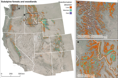
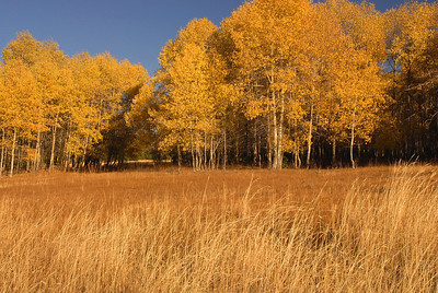
High agreement on a transformation outcome is not reassurance — it is a signal of high model confidence in that change. When the model strongly agrees that a location’s future climate will support a fundamentally different vegetation type, that is a signal of high confidence in transformation—not reassurance. Preparing for that change, rather than resisting it, may be the more realistic path.

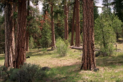
Low agreement, on the other hand, does not necessarily mean bad data. It means that multiple vegetation types are climatically plausible at that location. The model is surfacing real biological redundancy—multiple communities can be supported by the same climate—and the vegetation type that ultimately emerges depends on disturbance, seed sources, management, and chance. Low agreement can also indicate that factors other than climate are the stronger driver of vegetation at that location, which is itself important information for managers deciding where and how to intervene.

Vulnerability × Agreement Matrix

Decision Support Framework

Vulnerability × Agreement Matrix

The combination of projected transformation likelihood and model agreement defines four decision contexts for the western United States.

High Agreement
Low Agreement
67% of study area Maintain & Monitor

Climate change alone is unlikely to drive transformation here, and the model is consistent in that assessment. Fuel management, diversity maintenance, and monitoring are well-supported by the evidence.

26% of study area Prepare for Transition

Transformation is both projected and the primary projection is well supported. Disturbance events are likely to catalyze transitions to new vegetation communities. Prepare for, respond to, or initiate change.

4% of study area Watch for Change

The future climate may continue to support current vegetation, but model support is distributed. Monitor for directional signals and maintain resilience.

3% of study area High Leverage — Act Locally

Multiple divergent trajectories are plausible. Climate alone does not determine outcomes — disturbance history, seed sources, and management may be decisive. Place-based knowledge is essential.

Low / Moderate
Vulnerability
High / Very High
Vulnerability

Decision contexts defined by transformation vulnerability and projection agreement across the western U.S. Percentages represent share of study area in each quadrant. Thresholds follow Hoecker et al. (2026, Global Change Biology).

The vulnerability × agreement matrix.  As shown in the matrix above, the combination of vulnerability and agreement defines four decision contexts across the western United States. Each reflects a different relationship between the likelihood of transformation and the certainty of that assessment.

  • Low or moderate vulnerability + high agreement (67% of study area)1. Climate change is unlikely to drive vegetation transformation at these locations, and the model is consistent in that assessment. Management approaches that maintain ecosystem resilience — fuel management, diversity maintenance, monitoring — are well-supported by the evidence.
  • High or very high vulnerability + high agreement (26% of study area)1. Transformation is both projected and the likely replacement vegetation type is clear. Disturbance events at these locations are likely to initiate transitions to fundamentally different vegetation communities. Management strategies oriented toward preparing for, responding to, and where appropriate, directly initiating, change are most appropriate here, given the strength of the climate signal.
  • High or very high vulnerability + low or moderate agreement (3% of study area)1. Transformation is projected and multiple divergent vegetation trajectories are plausible. Climate alone does not determine the outcome at these locations — disturbance history, seed sources, and management interventions may be decisive factors. Place-based knowledge is essential to interpreting what the projections mean for specific sites.
  • Low or moderate vulnerability + low or moderate agreement (4% of study area)1. The future climate may continue to support current vegetation, but model support is distributed. Monitoring and resilience maintenance are appropriate strategies, with attention to signals of directional change.

The Resist–Accept–Direct framework: a Natural Companion

The Resist–Accept–Direct (RAD) framework, developed through the Federal Navigating Ecological Transformation (FedNET) working group — spanning the National Park Service, Climate Adaptation Science Centers, USFWS, and partner agencies — provides a structured vocabulary for responses to ecological transformation4. Resist means working to maintain current conditions or slow the pace of change. Accept means allowing ecological transformation to proceed without active intervention. Direct means actively shaping the trajectory of change toward preferred outcomes.

RAD is not a decision tree or a stand-alone planning process. Instead it’s a lens that fits within existing adaptive management frameworks, helping managers ask: Given what we know about this place, which pathway makes sense right now—and when should we reassess?

The Vegetation Futures data layers map naturally onto RAD thinking—not as prescriptions, but as evidence to inform the conversation. Where vulnerability is high and agreement is high, the evidence base for accepting or directing is strongest. Where vulnerability is low, resilience-building activities to resist change are data-supported. Where agreement is low, directing — intervening to shape which trajectory unfolds — carries the most potential, but also the most dependence on local knowledge, stakeholder values, and management objectives.

Managers choose among plausible trajectories, not between right and wrong outcomes. The Vegetation Futures data informs that choice. It does not make it.

APPLIED USE CASE: A Manager's View

Climate projections only matter if they help someone make a decision. This section walks through an illustrative scenario — how a planning team at the Ochoco National Forest might use the Vegetation Futures tool to think through a real landscape challenge — as one example of the kind of reasoning the tool is designed to support.

The Ochoco sits at an elevation crossroads.

Across its 850,000 acres northeast of Bend, the landscape transitions from high-desert steppe and grassland at lower elevations through ponderosa and mixed-conifer forests to subalpine communities near the ridgelines. It's a forest that already contains multiple climate futures within its own boundaries — and the Vegetation Futures tool makes those differences visible.

Photo: USDA Forest Service, Pacific Northwest Region

Photo: USDA Forest Service, Pacific Northwest Region

At lower elevations, where invasive annual grasses (cheatgrass, ventenata, medusahead) have already pushed into perennial grasslands and sagebrush, the tool projects continued pressure toward non-forest and grass-dominated states. If model agreement is high in this zone, the signal for a planning team would be clear: the window for resistance is narrow, and protecting what remains of native perennial cover — rather than expecting recovery of historical conditions in already-invaded areas — may be the more sustainable goal. That's an accept-or-direct posture in RAD terms, redirecting investment toward what the landscape can realistically sustain.

At mid-elevations, the picture is more complex. Ponderosa pine and mixed-conifer forests face high projected vulnerability under a warmer climate scenario, but where model agreement on the specific future vegetation type is lower, that uncertainty isn't a reason to delay action — it's a reason to choose treatments that preserve options. Prescribed fire and thinning that reduce stand density and fuel loads increase the likelihood of maintaining open fire-tolerant conifer forests and woodlands. The tool helps a team locate where that kind of flexible, resilience-building investment has the most decision support behind it.

Photo: USDA Forest Service, Pacific Northwest Region

Photo: USDA Forest Service, Pacific Northwest Region

At higher elevations, subalpine communities show strong projected vulnerability with potential agreement toward dry forest or shrub analogs. Here, the RAD calculus shifts again — where transformation appears both likely and largely irreversible at human timescales, the planning question becomes: what ecological functions can be maintained during transition, and where should new planting investments be concentrated to reflect where subalpine species are likely to persist?

The tool doesn't offer easy answers in the Ochoco. But working through plausible futures illustrates something important: a spatially explicit, uncertainty-transparent framework can help a planning team differentiate which parts of a complex landscape warrant resistance, which warrant active direction, and which may benefit most from adaptive acceptance — rather than applying a single management posture across a heterogeneous landscape.

Try it yourself: scroll up above, or open the Vegetation Futures tool, zoom to the Ochoco NF, and toggle between primary and secondary projections. The gap between those two layers is where management decisions live.

 KNOW YOUR DATA

Resolution and Scale

These datasets are designed for stand- and landscape-scale planning at 30m pixel resolution. They do not support individual tree detection or precision forestry applications.

Interpretation Varies by Metric

Relative Density is designed to express stocking pressure relative to biological limits, not to serve as a precise threshold. In some regions, particularly along steep climatic gradients such as the Cascade and Sierra Nevada ranges, Relative Density values may change abruptly at ecoregion boundaries where modeled carrying capacity shifts. 

Relative density is not intended to be read as a precise percentage threshold. Instead, practitioners should interpret relative density in broad, ordinal zones that correspond to increasing levels of competitive stress and mortality risk. Small differences in relative density values should not be over-interpreted. Instead, the strength of the metric lies in its ability to distinguish forests with room to grow from those approaching or exceeding levels where competition-driven stress becomes likely. Used this way, relative density provides a shared language for discussing forest vulnerability without requiring region-specific stocking rules or incompatible local metrics.

Live Trees Only

All three datasets characterize standing live trees. They do not represent dead trees, coarse woody debris, or downed material, and they are not suitable for post-fire salvage assessment or disturbance forensics.

Large-Tree and Old-Growth Considerations

In stands dominated by larger trees, growing space is often not reoccupied quickly following mortality. As a result, density-related stress can emerge at lower relative density values than in younger stands. Current estimates of maximum stand density may therefore understate vulnerability in some large-diameter or old-growth forests.

Limitations and Context

Urban-adjacent forests may show localized anomalies near buildings or infrastructure. Herbaceous wetlands and flooded agricultural areas can occasionally produce outlier predictions. Land cover masks reduce—but do not fully eliminate—these effects.

More broadly, it’s worth being clear about what the merchantable timber dataset does—and does not—change. Information about timber volumes and wood supply already exists through industry, state, and federal agency channels, often with far more operational detail. What this dataset provides is greater transparency and consistency in public-interest planning by placing forest product information alongside ecological condition, stocking pressure, and risk—rather than treating it as a standalone signal. How this information is used ultimately depends on governance, values, and local knowledge. The data inform decisions; they do not make them.

looking ahead

This work represents one projection horizon: mid-21st century warming. Future iterations may incorporate additional warming scenarios, updated climate data, expansion into new geographies, and refined methods. The researchers have been explicit that it is one input among several. Local knowledge, site-level monitoring, fire history, species distributions, cultural values: these are not supplements to the model. They are the context that determines what the model's projections actually mean for a specific place.

The Vegetation Futures work was built to open questions for managers, not close them. The most important questions remain the ones only practitioners can answer: What trajectory is acceptable here? What is the cost of being wrong? When should we reassess?

Those questions have always been present. What's changed is how precisely we can ask them.

Smoke rises above the Pomas Fire in the North Cascades, July 2025. High-severity fire in subalpine terrain illustrates the disturbance dynamics that interact with — and can accelerate — the climate-driven transformation this research projects. Photo: USDA Forest Service, Okanogan-Wenatchee National Forest / InciWeb

Explore the Data Behind the Story

The full Vegetation Futures dataset — primary and secondary vegetation projections, transformation vulnerability, projection agreement, and climate variables — is freely accessible for the entire western United States. Whether you're a land manager assessing a specific unit, a researcher working at regional scale, or a planner building climate adaptation strategies, the tool lets you draw your area of interest and generate a downloadable report.

*This data story interprets research led by Tyler Hoecker and colleagues at the University of Montana, USFS Missoula Fire Lab, and Conservation Science Partners. The Vegetation Futures Tool was built by Gage Cartographics and is hosted at vegetationfutures.org. The underlying datasets are archived at OSF (doi: 10.17605/OSF.IO/4PU5X). The research was supported by the Northwest and North Central Climate Adaptation Science Centers, with contributions from the USDA Forest Service. This interpretive story was produced by Vibrant Planet Data Commons.

References

1. Hoecker, T. J., Davis, K. T., Littlefield, C., Chandler, J., Parks, S., Maguire, A., Kemp, K., Yegorova, S., & Dobrowski, S. (2026). Alternative future vegetation pathways reveal potential transformations of western US ecosystems. Global Change Biology. https://doi.org/10.1111/gcb.70795

2.  The four climate variables used to assess analog similarity are cumulative actual evapotranspiration, climatic water deficit, mean July maximum temperature, and mean January minimum temperature. See: Dobrowski, S. Z., C. E. Littlefield, D. S. Lyons, et al. 2021. “Protected-Area Targets Could Be Undermined by Climate Change-Driven Shifts in Ecoregions and Biomes.” Communications Earth & Environment 2, no. 1: 198. https://doi.org/10.1038/s43247-021-00270-z

3. TopoTerra is a topographically downscaled climate product derived from TerraClimate. Dataset: Hoecker, T. J., et al. (2025). Vegetation Futures Tool. University of Montana / Northwest CASC / North Central CASC / USDA Forest Service. https://doi.org/10.17605/OSF.IO/W6JVK. Climate baseline: Abatzoglou, J. T., Dobrowski, S. Z., Parks, S. A., & Hegewisch, K. C. (2018). TerraClimate, a high-resolution global dataset of monthly climate and climatic water balance from 1958–2015. Scientific Data, 5, 170191. https://doi.org/10.1038/sdata.2017.191. See also: https://www.climatologylab.org/terraclimate.html

4. Schuurman, G.W., Hawkins Hoffman, C., Cole, D., Lawrence, D., Morton, J., Magness, D.R., Cravens, A.E., Covington, S., O'Malley, R., and Fisichelli, N.A., 2020, Resist-accept-direct (RAD)-A framework for the 21st-century natural resource manager: Natural Resource Report 2020/2213, v, 20 p., https://doi.org/10.36967/nrr-2283597

5. A. J. Lynch et al., Managing for RADical ecosystem change: applying the Resist–Accept–Direct (RAD) framework. Frontiers in Ecology and the Environment 19, 461–469 (2021). https://doi.org/10.1002/fee.2377